This Boundary County genealogy page is part of the IDGenWeb and USGenWeb Projects.
This project is non-commercial and completely run by volunteers, part of a group working to provide family history research web sites for every county in the United States.
Thank you for visiting. Please, let us know how we're doing.
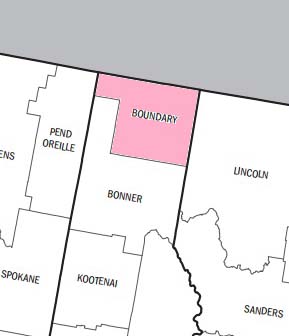
Boundary County is located in the Panhandle of Idaho
Main Cities include: Bonners Ferry, Eastport, Moyie Springs, Naples and Porthill
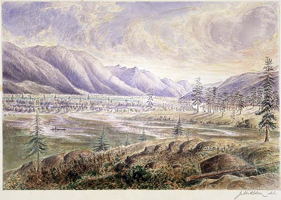
Kootenay River Valley by James Alden c1859
We hope our website will assist you in your genealogy research and you will find information to help your family history come alive.
Community Histories
County Community Maps
Boundary County was established January 23, 1915 with the County Seat at Bonners Ferry. The name Boundary was chosen as the county has boundaries with Canada and two states -- Washington and Montana. It borders only one other Idaho County -- Bonner Co. to the South.
Historical Background
"Boundary County was first part of Kootenai County, and then was split from Bonner County. It's early history is part of that of the original Kootenai County. David Thompson who was the first known white man in what is now Boundary County, opened up the fur trade in Idaho in 1808. In 1864, E. L. Bonner established a ferry on the Kootenai River at what is now Bonners Ferry. Richard Fry bought out Bonner in about 1874, and for 10 years the Fry brothers and their families were the only white people in the county. The first post office was named Fry, but later the name was changed to Bonners Ferry. The Great Northern Railroad was built through the area in the 1880's." -- "Idaho Almanac," published by the State of Idaho in 1977.
The tribal headquarters of the Kutenai Indians is a short distance from Bonners Ferry.
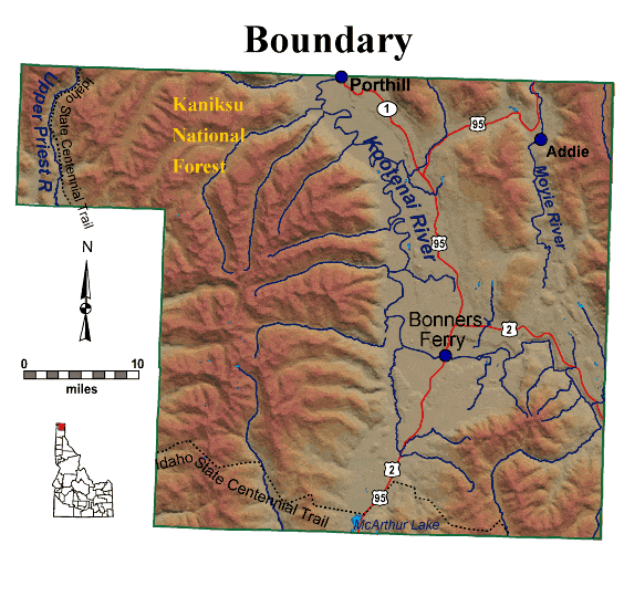
Geography
History and spectacular scenery abound here in Boundary County. The county is mountainous and forest covered terrain; the Selkirk and Cabinet Mountains being prominent ranges. The L-shaped Kootenai River Valley (approximately 30% of the county) is privately owned, the rest being either State or Federal property. Elevation ranges from 1740' in the valley to 7357' on Gunsight Peak in the Selkirks. The Ponderay National Forest became the Kaniksu National Forest in 1933, and is now known as the Panhandle National Forest. The Kootenai River rises in British Columbia, loops into NW Montana, circles through Boundary Co., then North into Kootenai Lake, in B.C., becoming the head waters of the Columbia River. The Moyie River starts in British Columbia, and joins the Kootenai River at Moyie Springs.
Idaho State University Boundary Co. Information
Search all of Boundary County - IDGenweb
| search engine by freefind |
Maintained by Randy Cummings, Boundary County Coordinator
If you would like to add resources, know of something that should be linked here or if you have any problems using this website, please contact us
Contributors as listed on individual links.
Updated January 2024 - Site Update History
Whats New - Page Update History
Copyright Notice: All materials contained on these pages are furnished for the free use of those engaged in researching their family origins. All images used on these pages were obtained from sources permitting free distribution, or generated by the author, and are subject to the same restrictions/permissions. All persons contributing material for posting on these pages do so in recognition of their free, non-commercial distribution, and further, is responsible to assure that no copyright is violated by their submission.
Any commercial use or distribution of these pages is prohibited.
Main Menu
- Welcome!
- Whats New!
- Website Updates
- Search
- Sitemap
- Cemeteries
- Obituaries
- Vital Records
- History Articles
- Index - History Articles
- Newest History Articles
- Community History
- Kootenai Tribe
- Boundary Schools History
- Pioneers & Biographies
- Pioneers
- 1903 History of Northern Idaho
- Resources & Links
- Local Resources
- How to Contribute and Volunteer
- County Maps
- Kootenai Tribe of Boundary
- Boundary County Newspapers
- Records at LDS Family History Centers
- Boundary County Books
- Other Resources
- Genealogy Links
- Surnames & Queries
- Photos
- Index - Photo Gallery
- Newest Photos
- Community Photos
- Photos of People
- Historic Photos
- Scenic Photos
- Boundary County Postcards

Our Neighbors
GenWeb Archives

Recent History Posts

Ancient City of Crossport
Nov 20, 2017
Eastport, Idaho
Sep 29, 2016
Recent Photos
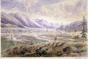
Kootenay River Valley by Alden
Feb 17, 2017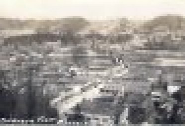
1927 Birdseye View of Bonners Ferry
Feb 17, 2017